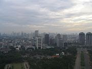
 Jakarta
(also
Djakarta or
DKI Jakarta), formerly known as
Sunda Kelapa,
Jayakarta and
Batavia is the
capital and largest city of
Indonesia. Located on the northwest coast of the
island of
Java, it has an area of 661.52 km² and a population of 8,792,000 (
2004).
[2] Jakarta was founded almost 500 years ago and currently is the eleventh largest city and metropolitan area and ninth
most densely populated city in the world with 44,283 people per sq mile.
[3] Its metropolitan area is called
Jabotabek and contains more than 23 million people, and is part of an even larger Jakarta-
Bandung megalopolis.
Jakarta is served by the Soekarno-Hatta International Airport. Since 2004, Jakarta, under the governance of Sutiyoso, has built a new transportation system, which is known as "TransJakarta" or "Busway" and in 2007, Jakarta will establish its newest transportation system, the Jakarta Monorail. Jakarta also is the location of the Jakarta Stock Exchange and the National Monument.
History
 Dutch Batavia in the 17th Century, built in what is now North Jakarta
The earliest recorded mention of
Jakarta is as a port of origin that can be traced to a Hindu settlement as early as the 4th century. By the 14th century, it was a major port for the
Hindu kingdom of Sunda. The first
European fleet, four
Portuguese ships from
Malacca, arrived in 1513 . Batzaush had been conquered by
Alfonso d'Albuquerque in 1511 when the Portuguese were looking for
spices and especially
pepper.
The relationship between the Kingdom of Sunda and Portugal intensified when another Portuguese named Enrique Leme visited Sunda in 1522 with the intention of giving a present. He was well-received and as a result, the Portuguese gained rights to build a warehouse and expand their fort in Sunda Kelapa (the name of the location at the time). The Sundanese regarded this as a consolidation of their position against the raging Muslim troops from the rising power of the Sultanate of Demak in Central Java.[4]
In 1527, Muslim troops coming from Cirebon and Demak attacked the Kingdom of Sunda under the leadership of Fatahillah. The king was expecting the Portuguese to come and help them hold Fatahillah's army because of an agreement that had been in place between Sunda and the Portuguese. However, Fatahillah's army succeeded in conquering the city on June
22, 1557, and Fatahillah changed the name of "Sunda Kelapa" to "Jayakarta" ("Great Deed" or "Complete Victory").[4]
The Castle of Batavia, seen from West Kali Besar by Andries Beeckman circa 1656-58
The followers of the Sultan of Banten (the location of Jayakarta), Prince Jayawikarta, was also very involved in the history of Jakarta. In 1596, many Dutch ships arrived in Jayakarta with the intention of trading spices, more or
less the same as that of the Portuguese. In 1602, the British East India Company's first voyage, commanded by Sir James Lancaster, arrived in Aceh and sailed on to Bantam where he was allowed to build trading post which becomes the centre of British trade i n Indonesia until 1682.[5] In this case, the Prince took the Dutch arrival seriously as the Dutch had constructed many military buildings. Prince Jayawikarta apparently also had a connection with the English and allowed them to build houses directly across from the Dutch buil
dings in 1615 . When relations between Prince Jayawikarta and the Dutch later deteriorated, his soldiers attacked the Dutch fortress which covered two main buildings, Nassau and Mauritus. But even with the help of 15 ships from the English, Prince Jayakarta's army wasn't able to defeat the Dutch, for Jan Pieterszoon Coen (J.P. Coen) came to Jayakarta just in time, drove away the English ships and burned the English trading post.
Batavia c.1870
Things then changed for the Prince, when the Sultan of Banten sent his soldiers and summoned Prince Jayawikarta to establish a close relationship with the English without an approval of the Banten authorities. The relationships between both Prince Jayawikarta and the English with the Banten government then became worse and resulted in the Prince's decision to move to Tanara, a small place in Banten, until his death. This assisted the Dutch in their efforts to establish a closer relationship with Banten. The Dutch had by then changed the name to "Batavia", which remained until 1942.[4]
Administration
Officially, Jakarta is not a city but a province with special status as the capital of Indonesia. It is administered much as any other Indonesian province. For example, Jakarta has a governor (instead of a mayor), and is divided into several sub-regions with their own administrative systems. Jakarta, as a province, is divided into five cities (kota) (formerly municipality (kotamadya)) each headed by a mayor and one regency (kabupaten) headed by a regent. List of
cities of Jakarta:
The only regency of Jakarta is:
Culture
As the economic and political capital of Indonesia, Jakarta attracts many foreign as well as domestic immigrants. As a result, Jakarta has a decidedly cosmopolitan flavor and a diverse culture. Many of the immigrants are from the
other parts of Java, bringing along a mixture of dialects of the Javanese and Sundanese languages, as well as their traditional foods and customs. The Betawi (Orang Betawi, or "people of Batavia") is a term used to describe the descendants of the people living around Batavia from around the 18th century. The Betawi people are mostly descended from various Southeast Asian ethnic groups brought or attracted to Batav
ia to meet labour needs, and include
people from various parts of Indonesia. The language and culture of these immigrants are distinct from those of the Sundanese or Javanese. There has also been a Chinese community in Jakarta for centuries. Officially they make up 6% of the Jakarta population, though this number may be under reported.[6]
Jakarta has several performance centers, such as the Senaya
n center. Traditional music is often found at high-class hotels, including wayang and gamelan performances. As the largest Indonesian city, Jakarta has lured much regional talent to relocate in hope of finding a greater audience and more opportunities for success.
The concentration of wealth and political influence in the city means that it has much more noticeable foreign influence on its landscape and culture, an effect illustrated by the presence in the city of many major international fast-food chains, for example.
Transportation

There are railways throughout Jakarta; however, they are inadequate in providing transportation for the citizens of Jakarta. In peak hours, the number of passengers simply exceeds the capacity. The railroad tracks connect Jakarta to its neighboring cities: Depok and Bogor to the south, Tangerang and Serpong to the west, and Bekasi, Karawang, and Cikampek to the east. The major rail stations are Gambir, Jatinegara, Pasar Sen
en, Manggarai, Tan
ah Abang and Jakarta Kota.
The busway takes less than half an hour to traverse a route which would normally take more than an hour during peak hours. Construction of the 2nd and 3rd corridor routes of the busway was completed in 2006, serving the route from Pulogadung to Kalideres. The busway serving the route from Blok M to Jakarta Kota has been operational since January 2004.

Jakarta traffic
 Despite the presence of many wide roads, Jakarta suffers from congestion due to heavy traffic, especially in the central business district. To reduce traffic jams, some major roads in Jakarta have a 'three in one' rule during rush hours, first introduced in 1992, prohibiting
less than three passengers per car on certain roads.
In 2005, this rule covered the Gatot Subroto Road.
This has presented an economic opportunity in that if there are only two people in the car, a "joki" (meaning "jockey") will offer to sit in the car as it travels through the restricted area. This currently costs around Rp5000, and there are many jockeys at every entry point to the restricted area.
To reduce traffic congestion, a new TransJakarta bus system was introduced.
Jakarta's roads are notorious for indisciplined driver behavior; the rules of the roa
d are broken with impunity and police bribery is commonplace. The painted lines on the road are regarded as mere suggestions as vehicles often travel four or five abreast on a typical two-lane r
oad and it is not uncommon to encounter a vehicle traveling the wrong direction in a given traffic flow. Furtherm
ore, in recent years the number of motorcycles on the streets has been growing almost exponentially, ensuring many a problem due to ill-disciplined motorcyclists. The vast sea of small, 100-200cc motorcycles, many of which have 2-stroke motors, create much of the traffic, noise and air pollution that plague Jakar
ta.
An outer ring road is now being constructed and is partly operational from Cilincing-Cakung-Pasar Rebo-Pondok Pinang-Daan Mogot-Cengkareng. A toll road connects Jakarta to Soekarno-Hatta International Airport in the north of J
akarta. Also connected via toll road is the port of Merak and Tangerang to the west and Bekasi, Cibitung and Karawang, Purwakarta and Bandung to the east.
Two lines of the Jakarta Monorail are under construction: the green line serving Semanggi-Casablanc
a Road-Kuningan-Semanggi and the blue line serving Kampung Melayu-Casablanca Road-Tanah Abang-Roxy. In addition, there are plans for a two-line subway (MRT) system, with a north-south line between Kota and Lebak Bulus, with connections to both monorail lines; and an east-west line, which will connect with the north-south line at the Sawah Besar station. The current project, which began in 2005, has been halted due to a lack of funds and its future remains uncertain.
On 6 June 2007, the city administration started to introduce the Waterway, ane
w river boat servic
e along the Ciliwung river.[7] The move aims to reduce the traffic snarls in Jakarta. The two boat service, each with a capacity of 28 passengers travels 1.7 kilometres along the West Flood Canal between Halimun in South Jakarta and Karet in Central Jakarta.[8]
There are currently two airports serving Jakarta; They are Soekarno-Hatta International Airport (CGK) and Halim Perdanakusuma International Airport (HLP).
Soekarno-Hatta International Airport is used for both private and commer
cial airliners con
necting Jakarta with other Indonesian cities. It is also Indonesia's main international gateway. The airport is divided into 3 separate terminals. Terminal 1 serves all domestic airliners except Garuda Indonesia. Terminal 2 serves all foreign carriers and Garuda Indonesia (both domestic and international routes). Terminal 3 serves solely for hajj pilgrimage flights. Halim Perdanakusuma International Airport serves mostly private and presidential flights.
Motorised bajaj
 Cycle
Cycle
rickshaws, called becak, provide local transportation in the back streets of some parts of the city. From the early 1
940s to 1991 they were a common form of local transportation in the city. In 1966, an estimated 160,000 rickshaws were operating in the city; as much as fifteen percent of Jakarta's total workforce was engaged in rickshaw driving. In 1971, rickshaws
were banned from major roads, and shortly thereafter the government attempted a total ban, which substantially reduced their numbers but did not eliminate them. An especially aggressive campaign to eliminate them finally succeeded in 1990 and 1991, bu
t during the economic crisis of 1998, some returned amid less effective government attempts to control them.[9] The only place left in Jakarta where riding becak is permitted is the amusement park Taman Impian Jaya Ancol. The c
ycle rickshaw (becak) is now back in very low density numbers in Jakarta, but looks dramatically different than the old ones. Now they look almost like a cart with cycle
in the back without the paintings and artwork of the old becaks.
Education

Museum Arsip (Archive Museum), one of the museums in Jakarta.
Jakarta is the home of many universities, the oldest of which is the private-owned Universitas Nasional (UNAS)[10], much of which has now relocated to Pasar Minggu.
There are also many other private universities in Jakarta. As the largest city and the capital, Jakarta houses a large number of students from various parts of Indonesia, many of whom reside in dormitories or home-stay residences. Similarly to other large cities in developing Asian coun
tries, there is a large number of professional schools teaching a wide range of subjects from Mandarin, English and computer skills to music and dance.
[citation needed] For basic education, there are a variety of primary and secondary schools, tagged with public (national), private (national plus) and international schools.
Sports
Jakarta is home of several soccer clubs. The most popular of them is Persija, which regularly plays its matches in the Lebak Bulus Stadium. The biggest stadium in Jakarta is the Bung Karno Stadium with a capacity of 100,000 seats[11]. For basketball, the Kelapa Gading Sport Mall in Kelapa Gading, Nor
th Jakarta, with a capacity of 7,000 seats, is the home arena of the Indonesian national basketball team. Many international basketball matches are played in this stadium. The Senayan sports complex is comprised of several sport venues, which include the Bung Karno soccer stadium, Madya Stadium, Istora Senayan, a shooting range, a tennis court and a golf driving range. The Senayan complex was b
uilt in 1959 to accommodate the Asian Games in 1962.
Media
Newspapers
Jakarta has several daily newspaper such as Bisnis Indonesia, The Jakarta Post, Indo Pos , Seputar Indonesia, Kompas, Media Indonesia, Republik
a, Pos Kota, Warta Kota, and Suara Pembaruan.
Television
Government television: TVRI.
Private national television: TPI, RCTI, Metro TV, Indosiar, StarANTV, SCTV, Trans TV, Lativi, Trans 7, and Global TV.
Local television: Jak-TV, O-Channel, and Space-Toon.
Cable television: Indovision, ASTRO, TelkomVision, Kabelvision
Problems

A trash dump in Bantar Gebang, Bekasi
Like many big cities in developing countries, Jakarta suffers from major urbanization problems. The population has risen sharply from 1.2 million in 1960 to 8.8 million in 2004, counting only its legal residents. The population of greater Jakarta is estimated at 23 million, making it the fourth largest urban area in the world. The rapid population growth has outgrown the government's ability to provide basic needs for its residents. As the third biggest economy in Indonesia, Jakarta has attracted a large number of visitors. The population during weekends is almost double that of weekdays, due to the influx of residents residing in other areas of Jabotabek. Because of government's inability to provide adequate transportation for its large population, Jakarta also suffers from severe traffic jams that occur almost every day. Air pollution and garbage management is also a severe problem.
During the wet season, Jakarta suffers from flooding due to clogged sewage pipes and waterways. Deforestation due to rapid urbanization on the highland areas south of Jakarta near Bogor and Depok has also contributed to the floods. Among the worst flooding ever occurred in late 1996[12][13] when approximately 65% of Jakarta's total area was flooded[citation needed]. In the floods of 2 February 2007[14], losses from infrastructure damage and state revenue were at least 5.2 trillion rupiah (572 million dollars) and at least 85 people were killed [15] and about 350,000 people forced from their homes. [16]. Approximately 70% of Jakarta's total area was flooded


